Datei:113th US Congress House districts color.svg
Zur Navigation springen
Zur Suche springen

Größe der PNG-Vorschau dieser SVG-Datei: 800 × 464 Pixel. Weitere aus SVG automatisch erzeugte PNG-Grafiken in verschiedenen Auflösungen: 320 × 186 Pixel | 640 × 372 Pixel | 1.024 × 594 Pixel | 1.280 × 743 Pixel | 2.560 × 1.486 Pixel | 1.242 × 721 Pixel
Originaldatei (SVG-Datei, Basisgröße: 1.242 × 721 Pixel, Dateigröße: 3,9 MB)
![]()
Diese Datei und die Informationen unter dem roten Trennstrich werden aus dem zentralen Medienarchiv Wikimedia Commons eingebunden.
![]()
Beschreibung
| Beschreibung |
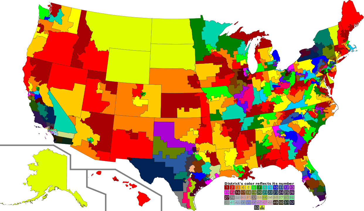
English: A map of all of the U.S. congressional districts (as of the 113th Congress). To find the district's number, look at the district, compare with the color code at the bottom to get number. The colors do not have any intrinsic meaning other than to provide visual distinction. |
| Datum | |
| Quelle |
Diese Datei wurde von diesen Werken abgeleitet: |
| Urheber |
|
| SVG‑Erstellung |
Lizenz
Diese Datei ist unter der Creative-Commons-Lizenz „Namensnennung 3.0 nicht portiert“ lizenziert.
- Dieses Werk darf von dir
- verbreitet werden – vervielfältigt, verbreitet und öffentlich zugänglich gemacht werden
- neu zusammengestellt werden – abgewandelt und bearbeitet werden
- Zu den folgenden Bedingungen:
- Namensnennung – Du musst angemessene Urheber- und Rechteangaben machen, einen Link zur Lizenz beifügen und angeben, ob Änderungen vorgenommen wurden. Diese Angaben dürfen in jeder angemessenen Art und Weise gemacht werden, allerdings nicht so, dass der Eindruck entsteht, der Lizenzgeber unterstütze gerade dich oder deine Nutzung besonders.
Ursprüngliches Datei-Logbuch
This image is a derivative work of the following images:
- File:US Congressional Districts color.svg licensed with PD-self
- 2009-09-14T22:28:34Z Mr. Matté 2583x1557 (1299871 Bytes) Fix western CA districts
- 2009-07-17T15:45:17Z Mr. Matté 2583x1557 (1280927 Bytes) Fix NY 26/27, make one path --> text
- 2008-08-21T02:52:58Z Mr. Matté 2583x1557 (1306679 Bytes) Fix Hawaii
- 2008-04-16T02:38:02Z Mr. Matté 2583x1557 (1366638 Bytes) Higher-quality, smaller version of the colored congressional map by district number
- 2008-02-06T23:06:44Z Mr. Matté 9111x5493 (1961159 Bytes) {{Information |Description=A map of all of the [[:en:List of United States congressional districts|U.S. congressional districts]] (as of the [[:en:110th United States Congress|110th Congress]]). To find the district's number
- File:113th U.S. Congress House districts blank.svg licensed with Cc-zero
Hochgeladen mit derivativeFX
Dateiversionen
Klicke auf einen Zeitpunkt, um diese Version zu laden.
| Version vom | Vorschaubild | Maße | Benutzer | Kommentar | |
|---|---|---|---|---|---|
| aktuell | 05:02, 31. Aug. 2012 | | 1.242 × 721 (3,9 MB) | Magog the Ogre | GA 02/08 accidentally transposed |
| 03:47, 31. Aug. 2012 |  | 1.242 × 721 (3,9 MB) | Magog the Ogre | {{Information |Description={{en|1=A map of all of the U.S. congressional districts (as of the 113th Congress). To find the district's number, look at the distric... |
Dateiverwendung
Die folgende Seite verwendet diese Datei:
Globale Dateiverwendung
Die nachfolgenden anderen Wikis verwenden diese Datei:
- Verwendung auf fa.wikipedia.org
- Verwendung auf fr.wikipedia.org
- Verwendung auf nl.wikipedia.org
- Verwendung auf sv.wikipedia.org